(Applied Geography, 2018)
Scratching the surface of war. Airborne laser scans of the Great War conflict landscape in Flanders (Belgium)
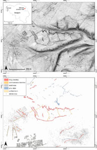
In light of the growing interest in the Great War – stimulated by the ongoing centennial commemorations – the conflict landscape in Belgium and France is currently the subject of scientific research projects, archaeological excavations, heritage-related initiatives and exhibitions. However, the extent of the archaeological heritage and surface remains of the Great War remain underestimated. Current heritage management and the proposal for a UNESCO nomination focus on the architectural heritage, commemorative monuments and military cemeteries, thereby overlooking the opportunities to acknowledge the conflict landscape in its totality. This paper explores the application of high-resolution Lidar data (DTM-Flanders II 2013–2015) to investigate a layer of war heritage which, until now, has remained invisible, and reveals a wide range of previously unknown archaeological sites related to the Great War. Traces of the war can be found all over the former front zones and hinterland, ranging from remnants of the heavily shelled and devastated war landscapes to more specific archaeo-geomorphological features of trenches, dugouts and other military infrastructure. Both the nature and the scale of the new information support and further expand the concept of the landscape as the last witness of the war.
Reference:
Gheyle, W., Stichelbaut, B., Saey, T., Note, N., Van den Berghe, H., Van Eetvelde, V., Van Meirvenne, M., & Bourgeois, J. (2018). Scratching the surface of war. Airborne laser scans of the Great War conflict landscape in Flanders (Belgium). Applied Geography, 90, 55-68.
https://authors.elsevier.com/a/1WAdKWf-B0Tv- (free access link until January 25, 2018)
https://www.sciencedirect.com/science/article/pii/S0143622817308287