(Geoderma, 2016)
EMI as a non-invasive survey technique to account for the interaction between WW I relicts and the soil environment at the Western front
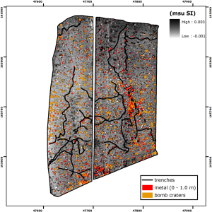
After the war, the greater part of the disturbed areas within the Western front zone of World War I (WW I) was taken back into culture. Even 100 years after date, it can be assumed that the soil within these areas still contains the traces of the war. To account for a thorough inventory of both the soil variability, the WW I relicts and the anthropogenic disturbances and to identify their interactions, a large-scale, non-invasive approach employing a multi-receiver frequency-domain EMI instrument was proposed. With this instrument, both lateral variations of the soil apparent electrical conductivity (σa) and apparent magnetic susceptibility (κa) from multiple overlapping soil volumes were obtained at a battlefield site within the Western front zone. Inverting the multiple simultaneous σa measurements allowed for a detailed representation of the depth to the interface between both contrasting loess and clay layers at the study site. Additionally, anomalies caused by buried metal objects could be separated from more subtle anomalies caused by shell holes. Moreover, inverting the κa measurements improved the identification of different WW I trenches. Finally, the integration of all WW I and soil features allowed for an enhanced understanding about the impact of the war activities on the soil environment and vice-versa.
Reference:
Saey, T., Note, N., Gheyle, W., Stichelbaut, B., Bourgeois, J., Van Eetvelde, V., & Van Meirvenne, M. (2016). EMI as a non-invasive survey technique to account for the interaction between WW I relicts and the soil environment at the Western front. Geoderma, 265, 39-52. doi: http://dx.doi.org/10.1016/j.geoderma.2015.11.020